

Moravian Cartographic Center

Address:
Zámek 14,
Velké Opatovice,
Czech Republic
Investor:obec Velké Opatovice
Project:1989-90
Completion:1992-2007
Built Up Area:1110 m2
Built Up Space:12540 m3
Much water has passed since I began dealing with the completion of the castle in Velké Opatovice. Implementing this project was a long and complicated process, where I, as a young architect, was confronted with the reality of realizing my vision.
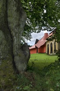
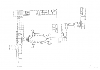
The castle complex in Velké Opatovice was built in the Neo-Baroque style in the mid-18th century. The complex has been owned by the municipality since 1934 and is intended for public use in the long term. In 1973, the southern connecting wing, which housed a school, burned down. Today, the castle houses the municipal office, as well as a cinema, restaurant, smaller cultural hall, and fitness center.
As part of the complete housing development, a grant was awarded to Velké Opatovice in the 1980s for the construction of a new cultural center. The new multipurpose hall was to be located in the courtyard of the castle, in the place of the burned wing. A number of variants developed by the then Stavoprojekt were questioned by heritage protectors. I, as an employee of the ÚHA (Institute of the Chief Architect) in Blansko, sketched a solution out of my own interest. Ultimately, the city leadership chose my design from a number of postmodern panel proposals. At a time when mass panel housing construction was finishing in the Czech Republic, this proposal was completely off the beaten track of typical construction output. The city’s leadership showed courage. We won the contract, and at the turn of the revolutionary years 1989/1990, this work found us in a newly established private company. I was 28 at the time, and this was my second private project after the construction of a swimming pool in Sloup in the Moravian Karst.
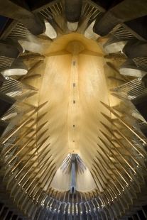
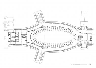
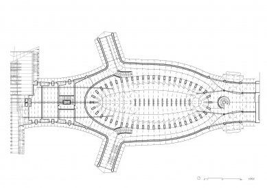
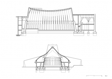
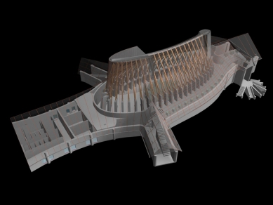
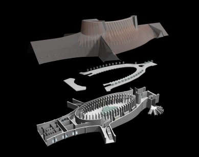
The building was initially designed as a response (an active dialogue) to the historical architecture of the castle, as a culmination of its calm Baroque composition. The realized design combines traditional construction, namely the truss, but also a supporting contemporary reinforced concrete structure, hidden under a concrete finish. Our proposed structural solution for the roofing of the hall predetermined the definition (the boundary) of the internal space as well as the external architectural form. In the elliptical floor plan shape, we arranged repeating reinforced concrete columns to which uniform-length rafters are anchored. Thanks to this geometric order, a convex and concave space of the hall was created. A draped ellipse. From the outside, the building was intended to resemble a wave, a new pulsating part of the castle, bridging the two fire-separated banks of the original Baroque layout.
After a year of construction, the building was halted in 1992, which was related to the limitation of state funding. The structure remained in a rough construction state for a long 13 years. Its fate was nearly sealed.
Hope for the salvation of the hall arose in 2004. At that time, the idea emerged to place a plastic map of Moravia and Silesia within the unfinished guts of the building, randomly found in the museum's depositary in Boskovice at the castle in Lysice. Thus, the idea of establishing the Moravian Cartographic Center was born. Our hall was directly created for this idea. It was enough to block the windows, slightly adjust the layout, and leave the hall in its raw construction form. The concrete cast and intended for plastering had weathered over the years. The construction technology processes could be read in the unfinished building. We decided to preserve this aesthetic, not to hide it. The interior features exposed concrete, unrefined raw wood, iron, and rough plaster colored directly in the core, without facade coatings. Similarly, we worked with the organization of the internal spatial structure. The basic scheme of the originally intended theater hall with balconies was retained, and a plastic map was placed on the "stage," which can be observed from a bird's-eye view from the balcony due to the twist of fate.
The final architectural form is a collage of my idealized vision of forbidden forms, the mystique of space, and my great, unfulfilled spatial desire that clashed with reality and time.
Today, the building serves the public.
The structure, bearing the marks of gradual decay but also subsequent completion, has recorded data in its walls similar to the wrinkles of an aging yet maturing person. These marks, maps on the walls, I decided not to cover with any cosmetic paint but to reveal them in all their morbidity. The concrete columns, floors, and walls thus bear the traces of actual development. They are filled with stained maps in which visitors can read rational data.
The castle complex in Velké Opatovice was built in the Neo-Baroque style in the mid-18th century. The complex has been owned by the municipality since 1934 and is intended for public use in the long term. In 1973, the southern connecting wing, which housed a school, burned down. Today, the castle houses the municipal office, as well as a cinema, restaurant, smaller cultural hall, and fitness center.
As part of the complete housing development, a grant was awarded to Velké Opatovice in the 1980s for the construction of a new cultural center. The new multipurpose hall was to be located in the courtyard of the castle, in the place of the burned wing. A number of variants developed by the then Stavoprojekt were questioned by heritage protectors. I, as an employee of the ÚHA (Institute of the Chief Architect) in Blansko, sketched a solution out of my own interest. Ultimately, the city leadership chose my design from a number of postmodern panel proposals. At a time when mass panel housing construction was finishing in the Czech Republic, this proposal was completely off the beaten track of typical construction output. The city’s leadership showed courage. We won the contract, and at the turn of the revolutionary years 1989/1990, this work found us in a newly established private company. I was 28 at the time, and this was my second private project after the construction of a swimming pool in Sloup in the Moravian Karst.
The building was initially designed as a response (an active dialogue) to the historical architecture of the castle, as a culmination of its calm Baroque composition. The realized design combines traditional construction, namely the truss, but also a supporting contemporary reinforced concrete structure, hidden under a concrete finish. Our proposed structural solution for the roofing of the hall predetermined the definition (the boundary) of the internal space as well as the external architectural form. In the elliptical floor plan shape, we arranged repeating reinforced concrete columns to which uniform-length rafters are anchored. Thanks to this geometric order, a convex and concave space of the hall was created. A draped ellipse. From the outside, the building was intended to resemble a wave, a new pulsating part of the castle, bridging the two fire-separated banks of the original Baroque layout.
After a year of construction, the building was halted in 1992, which was related to the limitation of state funding. The structure remained in a rough construction state for a long 13 years. Its fate was nearly sealed.
Hope for the salvation of the hall arose in 2004. At that time, the idea emerged to place a plastic map of Moravia and Silesia within the unfinished guts of the building, randomly found in the museum's depositary in Boskovice at the castle in Lysice. Thus, the idea of establishing the Moravian Cartographic Center was born. Our hall was directly created for this idea. It was enough to block the windows, slightly adjust the layout, and leave the hall in its raw construction form. The concrete cast and intended for plastering had weathered over the years. The construction technology processes could be read in the unfinished building. We decided to preserve this aesthetic, not to hide it. The interior features exposed concrete, unrefined raw wood, iron, and rough plaster colored directly in the core, without facade coatings. Similarly, we worked with the organization of the internal spatial structure. The basic scheme of the originally intended theater hall with balconies was retained, and a plastic map was placed on the "stage," which can be observed from a bird's-eye view from the balcony due to the twist of fate.
The final architectural form is a collage of my idealized vision of forbidden forms, the mystique of space, and my great, unfulfilled spatial desire that clashed with reality and time.
Today, the building serves the public.
The structure, bearing the marks of gradual decay but also subsequent completion, has recorded data in its walls similar to the wrinkles of an aging yet maturing person. These marks, maps on the walls, I decided not to cover with any cosmetic paint but to reveal them in all their morbidity. The concrete columns, floors, and walls thus bear the traces of actual development. They are filled with stained maps in which visitors can read rational data.
Fránek Architects
The English translation is powered by AI tool. Switch to Czech to view the original text source.


0 comments
add comment