Bike path above the Devil's Currents

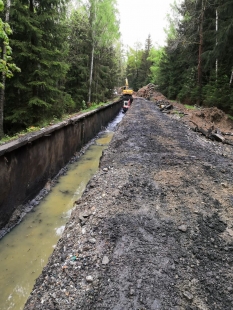
South Bohemia has a new section of the Vltava Cycle Path, measuring five and a half kilometers, which connects Loučovice with Vyšší Brod. The cycle path, designed by the A8000 studio and transportation engineer Ondřej Zenkl, was created from an uncovered and cleaned supply canal leading to the hydroelectric power station.
The route runs along the Vltava River, through the Čertova Stěna nature reserve. The cycle path between Loučovice and Vyšší Brod is not a new construction, but a transformation. The intervention in the landscape occurred long ago – a concrete canal was once built by humans as a water supply for the hydroelectric plant. Therefore, the A8000 studio does not act here as an architect in the sense of a creator-artist, but as an editor who has removed the excess and allowed the existing to speak. They do not come with the ambition to create new beauty but reveal the beauty that arose inadvertently. This highlights the fundamental idea of sustainability: not to destroy, not to build new, but to reflect on and transform what already exists.
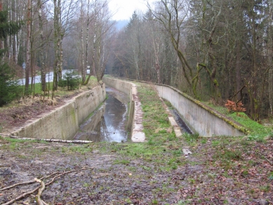
The project is based on the existing structure of the original technical construction – the historic Spiro Canal, a water supply for the Čertovy proudy hydroelectric power station by Ignác Spiro & Söhne, an unprecedented technical work at the time, which leads to the largest hydroelectric power station in Austro-Hungary. Today, a new route winds along the same structure, reading the landscape in a different way but with respect for the traces of the past. “The cycle path follows the route of the original historic reinforced concrete canal over a stretch of about 1.4 km. Cyclists will also pass through the interior of the canal, even crossing an aqueduct at this location. This is an amazing technical monument, which has transformed into a kind of curve in the landscape. From the beginning, we knew we had to rediscover and revive the canal. We also utilized the original concrete structures that are decades old. Most brownfields tend to be transformed into something else – for example, factories into apartments and offices. But we were fascinated by the story of this significant technical infrastructure, which, after nearly 70 years of neglect, serves again as infrastructure – just this time for transport,” says architect Martin Krupauer from the A8000 studio.
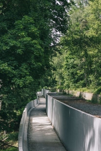
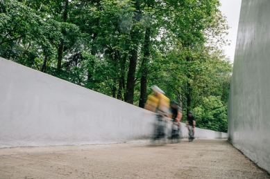
The most interesting part of the cycle path is the section that takes cyclists through the interior of the canal. It is a reinforced concrete monolith, running along a slope high above the flow of the Vltava. In the affected section, originally an aqueduct about 250 meters long, the canal was cleaned, locally statically reinforced, and adapted into a cycle path. The cycle path runs over the concrete bottom of the former canal, allowing people to pass through not only the landscape but also a technical unique feature referencing the history of this area. The intervention was minimal, and therein lies its strength. The body of the original canal was cleaned, and in the section of the original aqueduct, it was "cut" – the cut opened views into the green valley of the iconic Vltava's Čertovy proudy, and over time, the buried water canal became an open curve in the landscape. The shape of the path was not designed, but emerged as it was feasible and how it turned out. And that is exactly what makes it a landscape feature that does not strive to dominate but to blend in.
The concrete structure was neither suppressed nor masked. On the contrary, its mass and shape remained dominant. In some places, the right wall of the canal is taller than a person, resembling a massive rock, a channel carved into stone. The thickness of the walls ranges from 20 to 30 cm. The structure appears as a natural formation, having passed through time and landscape. The surface was unified with a coat of white paint, which, however, ages and gets dirty along with the environment – it does not create a contrast but disappears.
The path also serves as a tool for the strategic transformation of the entire area. Loučovice, once a vibrant paper-making community, is seeking a new identity and prosperity after losing industrial job opportunities. The cycle path is an impulse that attracts new entrepreneurs – cafes, bakeries, and the old pub are coming back to life. “We are finally getting onto the tourist map of Lipno. Our community has always been industrial, but the industry disappeared after the revolution. The new cycle path brings us great benefits. Entrepreneurs are coming forward who want to open businesses here,” adds Loučovice mayor Jan Kubík.
The cycle path begins at the chapel of St. Prokop in Loučovice, continues along the left bank of the Vltava, and passes through the municipality to the bridge. From there, it turns onto the right bank, along Čertova stěna, and leads across the historic Spiro water canal towards the Lipno II balancing reservoir. For now, the path ends at the Pod Hrází campsite in Vyšší Brod, where it will connect to further planned parts of the Vltava Cycle Path and other cycling routes in the region. Due to its convenient profile and attractive route, high usage is expected not only from recreational cyclists but also from local residents. The construction of the new cycle path cost over 90 million crowns and is part of a broader vision of the South Bohemia region to connect the entire Lipno area with cycling routes as far as Týn nad Vltavou. The cycle path is also part of the project Around and Around, in which local cycling enthusiasts map the paths around Lipno and its surroundings.
The English translation is powered by AI tool. Switch to Czech to view the original text source.
0 comments
add comment


