

President Pavel signed the law establishing the Czech Chamber of Surveyors
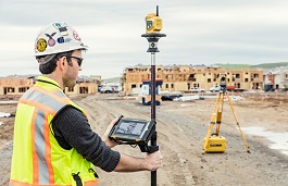 |
The Surveying Chamber will grant authorization for verifying the results of surveying activities used for the administration of the land registry, particularly geometric plans or documentation for marking land boundaries, activities utilized in construction, and for state maps. It will grant the title of "authorized surveying engineer."
According to the proposal, surveyors will obtain authorization with at least five years of practice after passing an exam, and the chamber would register them in the register of authorized surveying engineers. The chamber based in Prague will be led by a board elected by its assembly, and it will have a supervisory and authorization council. For disciplinary violations, the chamber could impose fines up to 50,000 crowns or revoke authorization.
The establishment of the chamber was initiated by the Association of Entrepreneurs in Geomatics with the support of the Czech Chamber of Architects, the Directorate of Roads and Highways of the Czech Republic, and the Railway Administration. The creation of the new professional organization was supported by the Ministry for Regional Development.
The government amendment also anticipates that all public authorities will now provide geographic data to the office, and conversely, all these institutions will have free access to it. "The aim is to create the prerequisites for the further development of geographically oriented information systems in public administration," the government stated in the justification of the amendment. According to the government, the Surveying Office is expected to lose approximately five million crowns per year in revenue. The state expects compensation from the benefits that should arise, for example, from taxing the activities of private entities, where the use of geospatial information will positively impact their revenues. Costs will also decrease as the office will not have to manage this data separately for other offices.
The English translation is powered by AI tool. Switch to Czech to view the original text source.
0 comments
add comment